Maps should not be trusted. At least not in Africa. For though they may show you that a road exists in theory, they cannot account for its actual state.
We learned this the hard way.
We had based an entire month of travel plans on the existence of a single road, through Zambia’s South Luangwa National Park. Rather than re-trace our steps north through Malawi to return to Tanzania, we would head into Zambia, safari our little hearts out, and then drive north through the park on the supposed road to reach the national highway that runs from Lusaka into Tanzania.
View Full Size Travel Map at Travellerspoint
The map declared this trip easy. What our map didn’t divulge was that this cross-Luangwa road required fording three rivers. This was going to be easier said than done.
“The riverbeds are really steep,” explained a ranger at our lodge. “You won’t be able to get up the sandy river edge until a truck comes and flattens them out.”
“When will that happen?”
“Once the water level of the last river goes down. See, that river runs all year, so we have to make a sandbag bridge there. But with the water still running so strong, the sandbags just float away.”
Oh. Our map hadn’t prepared us for this reality. At least we had time on our side – a blessing of flexibility that this travel style brings. So we decided to wait for the water level to go down – patience had always served us well.
.jpg) |
| I’m good at waiting patiently, see? |
“Have they sandbagged the river yet?,” we’d ask the rangers at the gate of the park each time we entered for safari. The answer was always no. Eventually we learned that the river generally gets sandbagged in June, and that this cross-Luangwa road was really only navigable a few short months of the year. It was only early May. We had time, but not that much time.
The only other option, it appeared, was to take a detour eastward, then north along the border of Malawi, up and over the mountains, and finally, west to meet the big highway just before the Tanzanian border.
View Full Size Travel Map at Travellerspoint
(The first and last point on the map would meet up directly if it weren’t for the rivers.)
This detour: an extra 900km.
This detour: an extra 900km.
That was what the map told us. What it didn’t – couldn’t – divulge was that this was a bad, bad road.
Bruno tried acquiring information on this road trip online, but it appeared that no one had tried to drive this way. Some had contemplated it, but fearing its inaccessibility, had made alternate plans.
We may not be the first tourists to attempt the Chipata – Lundazi – Isoka road, but we seem to be the first to write about it online. And what I can say, after a 4-day, 900km road trip with more than 400km of un-tarred road, is do not trust your map.
.jpg)
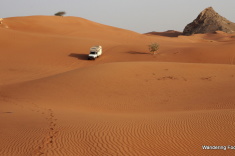
.jpg) |
| This is a normal road between Lundazi and Isoka. When the roads were REALLY bad, I was too busy bracing myself to take a photo! |
It was hard to focus on the sights that ambled bumpily past my window, for I was completely zoned-in on the road in front of me. I was as focused on the bumps, ripples, and ridges before us as if I were the one driving. But in fact, I was just trying to brace my body for the jolts, lest I get whip-lash or be thrown from my seat.
When I could look out at the windows, I mostly saw red dust. I know there were orchids and sunflowers and cotton flowers, but they had turned rust-red. The people who poked their heads out of the tall swaying grasses were dusted red, and the huts with patterns painted proudly along their bases were tinted red, too.

Rainy season had left its mark in this region. The road looked like undulating waves on a stormy sea. Except where the rain had simply swept the road away, so that we were driving on a strip of earth too narrow for the vehicle, with deep crevices on either end. In these moments, we were forced to set two tires into a crevice, and the vehicle would tilt precariously to one side. I’d inadvertently hold my breath and lean toward Bruno.
We drove over the fissures that the rainy season rivers had created on the road. We drove over the potholes left by the thick tires of stuck trucks. We drove over cemeteries of broken sticks thrown in disarray under tires to help vehicles climb out of the mud.
| Notice the wooden sticks dispersed along the road. |
But thankfully, we didn’t have to worry about mud. Not this time. That was, perhaps, the only saving grace of the trip.
We did, however, have to worry about accommodation. Because of the lack of tourism, there were no campsites between Chipata and Isoka, and no accommodation at all for the worst 400km stretch of road. Bush camping was going to be in order at least once.
Our first night, we lucked out, and got to camp in front of a real castle. The Lundazi Castle was built in 1949 on extensive grounds overlooking two rivers. It’s only the second castle I’ve seen in all of Africa, the first being in Namibia. For a few dollars, the manager let us spend the night in front of this national monument.
| Camped in front of Lundazi Castle. |
I was thankful to get a good night sleep at the castle, because the next day began the 400km dirt stretch of hell. We were averaging only 15-20 kmph, and the road was bouncing agonizingly slowly past. The road here was the outer boundary of Zambia so that, as we sat in the car, I was back in Malawi while Bruno was still in Zambia.
As the road passed into Malawi’s Vwaza Marsh Wildlife Reserve, the tsetses came. At first, just a few here and there, and then so many that we had to shut the windows and bear the stifling afternoon heat without the faint but merciful outdoor breeze. Tsetse flies were stuck along the hood of the car and plastered on the windows. Worse, at least forty were trapped inside our cabin, so that we were constantly swatting our legs and necks.
| This “flag” is loaded with chemicals. Tsetse flies are attracted to the color, fly to the flag, and die. I can’t even imagine what this part of Vwaza Marsh would have been like WITHOUT these flags… |
Tsetse fly bites hurt a lot, and their carapace is as strong as a knight’s armor. It’s almost impossible to kill them. When we opened the windows slightly to shoo them out, ten more would fly in. It was only by picking up speed whenever the road wasn’t horrendous (thereby out-running our pursuers), throwing open the windows, and swatting the imprisoned flies out that we eventually managed to have a tsetse-free cabin.
Needless to say, we breathed a sigh of relief that evening when we located a little uninhabited forest on the edge of the road a few kilometers outside of the little village of Muyombe. My first bush camp was about as good a location as we could have hoped for, but we slept fitfully, dreaming of the bumps we still had to face the following day.
| Bush camping in a forest outside of Myombe village. |
When the smooth tar appeared just before Isoka, it looked like a mirage. Driving at 80kmph felt like NASCAR race speed. The road felt almost too smooth.
I was finally able to look at something other than the road. But besides groups of school children, a few town shops, and a variety of goods for sale informally on the road (including black market diesel siphoned off of trucks and sold in jerry cans), there wasn’t much to see. Tar roads made everything seem less beautiful.
| The black market for diesel… No filling stations for 200km. |
| My favorite roadside shop. “Muzungu” means “white person” or “foreigner”. We get called “muzungu” on a daily basis. |
Plus, there were so many transport trucks taking up three quarters of the road that our attention was once again diverted. We certainly didn’t want to end up flipped over on the side of the road like so many of them.
| Trucks use branches from trees to signal to oncoming vehicles to merge into the next lane. |
When we finally rolled into Kapishya Hot Springs Lodge at the end of our four-day detour, it was with sore bodies, scrambled brains, and indescribable fatigue. After tsetse flies, bush camping, 400km of the worst road I’ve ever seen, daredevil truck drivers, and a map that had led us very-much astray, we deserved a good soak in the springs, wouldn’t you say?
| Warm natural hot springs, surrounded by lush forest, birds, and monkeys. |
Brittany Caumette - Yes, I remember being called a FARANG all the time! It seems every country has an endearing term for a foreigner!
We can usually find someone in East Africa who speaks English; though Tanzania was the most difficult. I ended up Learning some Kiswahili words for the local market without even meaning to! In Burundi and Rwanda (where we currently are – yes, I am behind on posts!) there is a lot of French, which also works for us.
It’s difficult to learn any other language than Kiswahili because each region and village speaks a different tribal language. Thankfully most signs are in English! 🙂
Clayton Roche - Ha, your comment about Muzungu made me laugh, as I can of course relate in Thailand being a “farrang.”
How is the English there? Have you learned much of the local language? Do they use the English alphabet? I suppose there are many languages..?